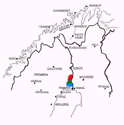
Maps of the Tornio River Valley Area

Sweden on the left side of the border, Finland on the right. Norway on top.
Red = Övertorneå Parish
Green = Hietaniemi Parish
Blue = Karl Gustaf Parish

The second map shows also, how the population was settled (established)
during the 1500s, and also where they have done archeological
investigations.

Map from Arvid Moberg's "Kopparverket i Kåfjord", 1968 (color-drawings only
on this picture to show these three Parishes by S. Torikka)

First Map | Second Map | Third Map

Why Did They Go            Finnish in Copper Country

Copper Country Online Files

Copper Country Online Files

Houghton MIGenWeb

Index | Archives | Bibliography | Bios | Cemeteries | Lookups | Obits | Queries 

Keweenaw MIGenWeb

Index | Archives | Bibliography | Bios | Cemeteries | Lookups | Obits | Queries

Join Us On FaceBook

  Web Page Coding: Copyright © 1998 - 2013. All rights reserved. Volunteers hold copyright to the material they have donated for this site.  Not to be copied and used in any format to any other site or in any other media including CDs, books, and visual presentations.  Small parts (not all one surnames studies) may be used in personal family genealogies.  Please cite your source (this site) when using this data. 

MIGenWeb Project


Hosted on the Michigan Family History Network Server